What We Learned When the City Came to Virginia Avenue
Seventy-five neighbors packed the Atlantic Boardroom at the Convention and Visitors Bureau on Tuesday afternoon. Standing room only. A 3:30 PM meeting on a workday, and every seat was taken.
They came because Planning Director Cathy Warren had promised to return with answers. At the March 4th Civic League meeting, Warren had attended but acknowledged she wasn't an engineer and couldn't answer the technical questions residents were raising about the proposed 24-unit condominium development at 1001 Virginia Avenue. She committed to bringing the experts.
She kept that commitment. Warren brought five senior staff members: Deputy Director Carrie Buchholdt, Zoning Administrator Hanna Szabo, Development Services Administrator Seth Edwards (a licensed professional engineer and certified floodplain manager with 20 years of city experience), Traffic Engineer Rick Loman, and Assistant City Attorney Tori Eisenberg. The Vice Mayor helped arrange the venue.
The meeting lasted about an hour. What residents heard was informative, professional, and in some cases deeply unsettling.
"This Is a By-Right Project"
Warren opened with the words that frame everything: "This is a by-right project, which means they don't have to get any discretionary approvals through Planning Commission or City Council to move forward."
The development is zoned A-18 (apartment district). Condominiums are a permitted use. The developer does not need a rezoning, a conditional use permit, or a public hearing. The site plan goes through an administrative review by city staff, and if it meets the code requirements, it must be approved.
A resident asked whether zoning ever expires. Warren's answer was direct: "Zoning runs with the land. It does not expire."
Even if conditions have changed. Even if the water has risen. Even if the neighborhood now has a park at the end of the street that didn't exist when the zoning was granted. The zoning stands.
One Year, Four Submittals, Fifteen Reviewers
Seth Edwards walked through the project timeline, revealing publicly for the first time the full submittal history:
| Date | Event |
|---|---|
| October 3, 2024 | Pre-submittal meeting with developer |
| April 18, 2025 | 1st Submittal |
| May 19, 2025 | City comments |
| July 21, 2025 | 2nd Submittal |
| August 20, 2025 | City comments |
| November 17, 2025 | 3rd Submittal |
| December 16, 2025 | City comments |
| February 6, 2026 | 4th Submittal |
| March 6, 2026 | City comments |
| ~April 2026 | 5th Submittal expected |
A 5th submittal is expected in the next couple of weeks. The project has been under continuous review for a full year, with deficiencies identified in every round.
Warren also revealed a recent legislative change: the state now gives the city 40 days for initial submittals and 30 days for subsequent reviews. She noted commercial projects typically require 4-5 submittals to reach approval.
Fifteen different city departments review the site plan — from DSC Engineering and Public Utilities to the Fire Department, Parks and Recreation, HRSD, Wetlands/Environmental, and the Zoning office. Warren noted: "Sometimes we route to five people. Sometimes we route and we can route up to 40."
"It's What the Builder Is Providing to Us"
The most revealing exchange of the afternoon came when a resident asked whether the city's review groups receive information from anyone other than the developer — flooding photos, wetland observations, anything from the community.
Warren's response: "It's what the builder is providing to us, because we're reviewing what they submit to us against our adopted regulations, ordinances, things that we can legally require to make them meet before approving a site plan."
A resident pushed back: "These reviewing groups aren't receiving information from anybody but the person who benefits from building millions of dollars."
Warren acknowledged the point: "We can certainly provide the information. It may not change, and it likely wouldn't change what the requirements are."
The implication landed hard. The requirements are in the ordinance. If the code doesn't require something — a wetland buffer, a tree replacement plan, an evacuation analysis, a traffic study — the city can't require it from the developer. And the fifteen reviewing groups don't go looking for information the developer doesn't provide.
The Stormwater System: 7,000 Cubic Feet Underground
Edwards, who has spent 20 years reviewing stormwater systems for Virginia Beach, gave the most detailed technical presentation. He was careful to set expectations: "I will say not necessarily fix or resolve or not necessarily all the answers that we want to see, but the answers as far as how our regulations exist and can be applied."
The proposed stormwater design uses underground storage chambers encased in gravel — about 7,000 cubic feet of storage. An Isolator Row filter catches pollutants before water passes through to the chambers. The system outfalls to the existing ditch, then flows under Virginia Avenue through four 36-inch pipes into Lake Rudee, through Rudee Inlet, and out to the Atlantic Ocean.
The developer is also purchasing nutrient credits for water quality — providing some treatment on-site while buying credits for the required 10-20% phosphorus reduction.
Edwards confirmed the system was modeled in the city's Master Drainage Study, which checks "every interconnected pipe, channel, overflow path through the street" to ensure "no increase in any flooding in a ten year or one hundred year storm event anywhere adjacent, upstream or downstream."
The 500-Year Problem
A resident cited Chimney Hill and Windsor Woods as neighborhoods where city-approved developments had flooded anyway. Edwards clarified that Hurricane Matthew in 2016 "was approximately a five hundred year storm event" when compounded with Tropical Storm Julia 19 days earlier. The models design for the 100-year event, not the 500-year event.
The admission raises an obvious question: if the standard is built to survive a 100-year storm, and the area has already experienced a 500-year event, what does "no increase in flooding" actually guarantee?
The Tidal Connection
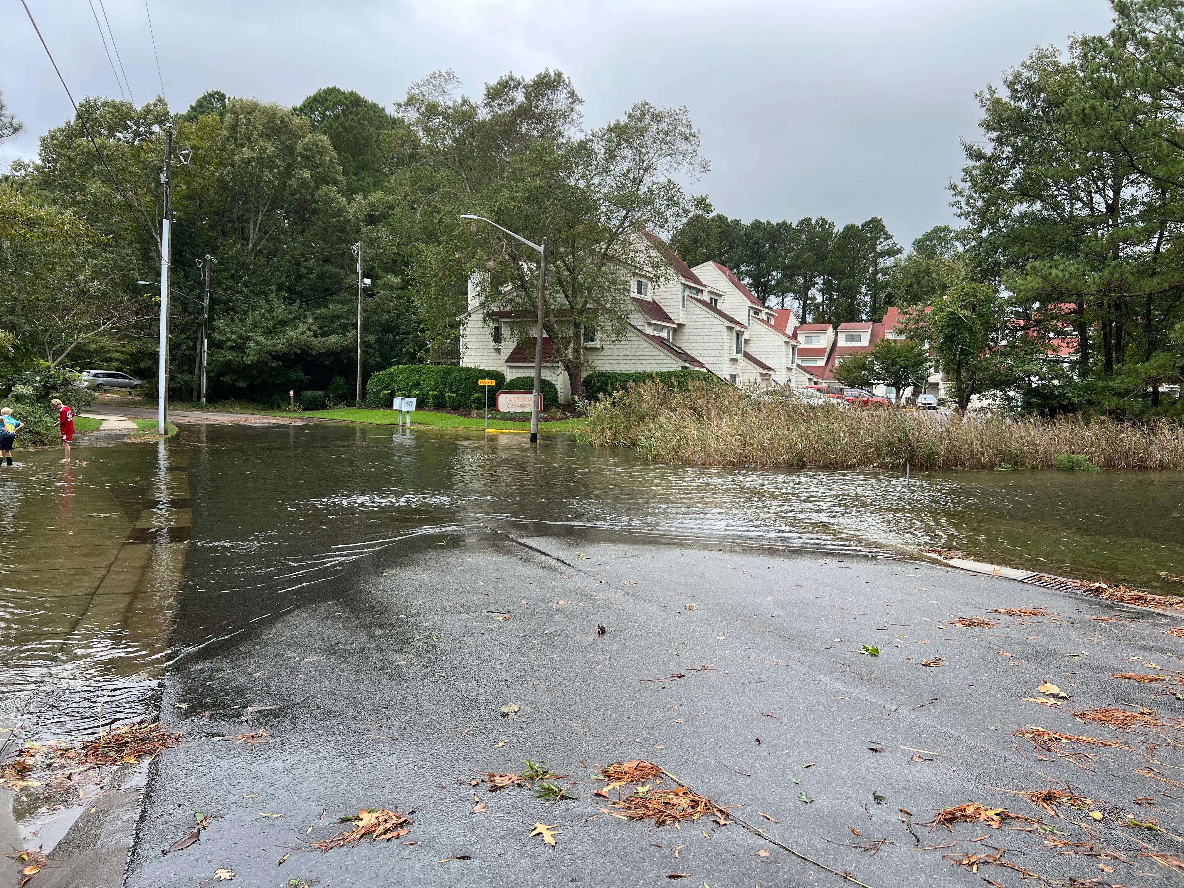
Then came a critical detail that got less attention than it deserved. Edwards confirmed: "It's directly connected to the tidal outfall. They're at Rudee Inlet. You're getting the high tide elevations from the Atlantic Ocean are directly impacting that roadway."
The tide elevation in the area reaches "the low fours." The FEMA 100-year flood elevation is set at seven feet. A resident pointed out that once water overtops Virginia Avenue, the tide connects directly to the ditch where the development's drainage goes. The underground chambers aren't just managing rainfall. They're contending with the Atlantic Ocean.
Edwards described the development's stormwater runoff relative to existing tidal flooding as "a drop in the bucket." But the resident's point was different: when the ocean is already in the ditch, where does the water from 7,000 cubic feet of underground chambers go?
The Army Corps Pond
A resident raised another significant point: "The property currently has a drainage pond, if you will, that I don't know if it's true or not, but someone said it was built by the Army Corps of Engineers. It's like an outlet."
Whether this is an Army Corps-constructed feature or a naturally occurring brackish pond, it currently functions as flood storage for the neighborhood. The development plan would eliminate it beneath 7 feet of fill.
839 Dump Trucks
The traffic presentation by Rick Loman explained why no formal traffic impact study was required: the ITE Trip Generation Manual shows the development will generate 16 trips in the AM peak hour and 20 in the PM peak hour, well below the 150-trip threshold.
The daily total is 160 trips — which actually exceeds the general threshold — but the metric that triggers a traffic study is peak-hour, not daily. So no study was required.
Then a resident changed the conversation.
"How many cubic feet of fill are they actually bringing in?"
Loman: "Based on the math, around ten thousand cubic feet."
"Do you know how many dump trucks that is?"
Loman: "I have no idea."
The resident had done the math: "It's eight hundred and thirty nine."
Each loaded dump truck puts roughly ten thousand times the load on the road as a passenger car. They'll come down Virginia Avenue, turn in, dump their fill, come back out. Eight hundred and thirty-nine times.
Another resident asked: "Is there any way to restrict the dump trucks during school bus time? I don't like the idea of eight hundred dump trucks driving up and down the street. We got kids standing on the corner waiting for buses."
There's a bus stop at Brady and Virginia. The city suggested moving the bus stop. A resident pointed out that moving the bus stop doesn't keep the trucks off the road where children walk.
The ITE Trip Generation Manual measures how many times residents drive in and out after the building is done. It does not measure 839 dump trucks during the construction phase. Nobody has evaluated what 28-ton trucks do to the culverts under Virginia Avenue or to the road surface itself. The threshold that determines whether a traffic study is required was never designed to evaluate construction traffic on a substandard-width dead-end residential street.
Cumulative Traffic: Nobody's Counting
A resident made a critical point about cumulative impact: "This street has had multiple condos or townhome developments over the years, to include a large park with a parking lot. Each one of those did not require a traffic study because at peak hours, it did not hit one hundred and fifty trips. But cumulatively over the years, as you're hearing from a lot of the neighbors, it has reached a lot of different trips."
The resident asked: "Is there a point or a threshold in which it does require a traffic study that would result in substantial change?"
The city's answer was effectively no. Each project is evaluated individually against the 150-trip peak-hour threshold. Cumulative impact from multiple developments on the same dead-end street is not evaluated.
Parking Already Lost
Another resident revealed a detail that went largely unnoticed: "The city already took two of my parking spaces to make the sidewalk. We used to be able to fit four cars. Now we can only fit two."
Virginia Avenue's parking capacity has already been reduced by city action. The new development's 51 parking spaces may be sufficient on paper, but overflow parking will push onto an already-constrained street where residents have fewer spaces than they started with.
The Ashville Park Question
A resident asked the city to explain what happened at Ashville Park — a Virginia Beach development where the city-approved stormwater system proved catastrophically inadequate after the 2016 storms, eventually requiring $11 million in taxpayer-funded remediation including pumping systems to move water to Back Bay. The developer went bankrupt. Taxpayers bore 72% of the repair cost.
The city did not answer the question.
The parallel is uncomfortable. Ashville Park's stormwater design was reviewed and accepted by city staff through the same process now reviewing 1001 Virginia Avenue. Councilmember Barbara Henley asked during the Ashville Park crisis: "Are we going to continue to go forward with development in areas that we know have serious potential for flooding?"
That question was not answered yesterday either.
The Sewer Question
A resident asked the practical infrastructure question: "You're going to put one hundred people in here, sewage-wise. Are they going to be on a private sewer system? And if not, how is the sewer system going to handle the output of one hundred people? Is it rated for that?"
The city staff acknowledged they weren't the right people for that question but said the utilities department "does an incredible job" checking capacity at each pump station. The answer was not about whether the system could handle it, but a reassurance that someone else checks.
What Was Not Discussed
The meeting covered three topics: site plan process, stormwater, and traffic. Several significant issues were never raised by city staff:
- The AICUZ >75 dB noise zone — the FAA designates residential as "Not Compatible" in this zone. The city has spent over $130 million removing residents from AICUZ noise zones. This was not mentioned.
- The blank USACE Form 6285 — the Army Corps certification submitted with the application is completely blank. No permit number, no signature, no authorization. Not mentioned.
- The zero-infiltration soil test results — the developer's own geotechnical consultant found zero soil infiltration capacity at all three test locations, yet the stormwater design relies on underground infiltration chambers. Edwards described how chambers work generically but never addressed the specific test results for this site.
- Endangered species — the site is in Virginia DWR's NLEB Year-Round Zone 1. No biological survey has been conducted. Not mentioned.
- The missing subdivision plat — cited in every city review letter since April 2025. The developer filed a plat in December 2025 and it was "Not Accepted." Not mentioned.
- Building height compliance — elevations have not been submitted across four review rounds. Not mentioned.
- Flood evacuation — no one has evaluated whether residents can safely evacuate a dead-end street during flooding. At the prior Q&A session, the city confirmed this is "not a function of site plan review."
"Single-Family" Classification
In the closing moments of the meeting, a side conversation revealed something that warrants investigation: the 24 units are being classified as "single-family attached homes" rather than multifamily condominiums.
This classification matters enormously:
- ITE Trip Generation: Single-family attached and multifamily use different rate tables. The trip count and threshold determination could change.
- Zoning code applicability: Different code provisions apply to single-family vs. multifamily structures.
- AICUZ compatibility: Article 18's noise compatibility table designates "multiple-family dwellings" as Not Compatible in the >75 dB zone, but single-family has different treatment.
If 24 three-story condominium units sharing common walls on a single parcel are being classified as "single-family attached" to clear regulatory thresholds, that is a significant issue worth investigating.
A Dead-End Sign
When residents raised concerns about speeding traffic on Virginia Avenue, the traffic engineer offered to install dead-end signage. There currently isn't any.
He also noted that the Civic League president could write a letter requesting a speed study and traffic calming for the street. If 85% of vehicles exceed 33 mph, traffic calming measures can be installed. A resident pointed out that DoorDash and Amazon delivery trucks are already among the worst speeding offenders.
It was a small, practical commitment — the kind of thing government does well. Install a sign. Study the speed. Respond to the request.
The larger questions — about who evaluates whether 839 dump trucks can safely share a dead-end street with school children, about who pays when a city-approved stormwater system fails, about whether the code has gaps that leave residents unprotected — those require more than a sign.
What Happens Next
The 5th submittal is expected within weeks. If it resolves the outstanding deficiencies, the site plan could be approved through the administrative process without any public hearing or council vote.
The full Community Review documenting 13 grounds of regulatory concern is available at shadowlawnva.com, along with the evidence gallery, FOIA document archive, and a public comment letter generator.
The petition has 922+ signatures.
Your District 5 council member is Rosemary Wilson — rcwilson@vbgov.com, (757) 713-3616.
To register to speak at City Council: call the City Clerk at (757) 385-4303.
Related
- When the City Approves a Flawed Design: The Ashville Park Precedent — What happened when Virginia Beach's stormwater review process failed 300 families
- Community Review: 13 Grounds for Regulatory Concern — The full evidence-based analysis of FOIA documents
- Civic League Q&A with City Staff (March 30, 2026) — Written questions and answers submitted before the meeting
- Take Action: Generate a Public Comment Letter — Select your concerns and generate a letter to city officials
Meeting Details
Date: March 31, 2026, 3:30 PM Location: Convention & Visitors Bureau, 600 22nd Street, 2nd Floor, Atlantic Boardroom Attendance: Approximately 75 residents (at capacity)
City Staff Present:
- Cathy Warren, Planning Director
- Carrie Buchholdt, Deputy Director of Planning
- Hanna Szabo, Zoning Administrator
- Seth Edwards, Development Services Administrator, PE, CFM
- Rick Loman, Public Works Traffic Engineer
- Tori Eisenberg, City Attorney's Office
Community:
- Blake Roberson, Shadowlawn Civic League President
- Vice Mayor (helped arrange venue)